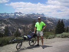
Here's a little video that I shot while Jodi, Django and I were climbing Nine Mile Canyon in the southern Sierras. This was uploaded using a new, trial blogger function, which I hope becomes a standard feature. It's so great to have everything in one place. No deep thoughts today. Just a fun clip.
Thursday, July 5, 2007
Wednesday, July 4, 2007
Inspiration

I've been thinking some about what keeps me motivated, what inspires all of us to get out there and live life intensely. I was blessed by a father who took me into the woods when I was young, hunting and hiking. While most of the other hunters who used the ranch would storm off in their 4X4's, Dad and I would rise at 4am, quietly pack our light day packs--he used to love those chewy, layered raisin cookies--shoulder our rifles, and slip off into the fog shrouded forest. The early, groggy feelings, the growing sense of excitement at the possibility of finding a deer or wild boar, the long, quiet walks through the oaks and tall grasses all filled me with a sense of wonder and connection with the outdoors that has never left me. We almost never got anything, though there were some exceptions, of course. The greater point was in the ritual, in spending time together, in blending into those grand and rugged hills.
Like an addict, I kept upping the dosage of my outdoor activities, and by the age of fifteen, I was hooked on rock climbing and mountaineering, but before that I had sampled some cycling in my local area. Once, at about the age of twelve or thirteen, a handful of us strapped sleeping bags to our bikes and pedaled many miles away, spent the night camped in the dunes by the Pacific, and pedaled home. That freedom and sense of power was an important lesson for me. Before we could drive, we could ride, and look how far we could go! Now, I'd rather ride than drive if I can help it. I've entered my second childhood, it seems, and none too soon. H. G. Wells said, "Every time I see an adult on a bicycle, I no longer despair for the future of the human race." Damn straight, old man. When gas is $40 a gallon, many more of us should rediscover the joys of the bicycle.
I did a couple of other overnight bicycle tours in my twenties, and once rode part of the Oregon and California coast but failed at my tour due to knee problems. I liked the idea of human power. I hiked and climbed all over the western US and Canada, and on one long drive up Hwy 395 just north of Susanville and headed for Canada, we passed a lone cyclist. There in the vast basin of sage and juniper was this single, solitary young man, a lean figure of muscle and sinew, baggy shirt and shorts flapping in the wind, his bike fully loaded with panniers front and rear. I found something so pure and fantastic about this unknown cyclist. He was up out of the saddle and pulling for glory, no motor, no sag wagon, just the dry wind and scent of sage to fuel his dream.
That image never left me, and I have since had the joys and pains of riding that same country and other wild, remote parts of the western states. The promise of his example has held true for me time and again. I am so grateful to have a spirit and body that allows me the privilege of such travel. To the sedentary public, our struggles often seem foolish, crazy, like, dude, why bother? Because, dude, it's a totally, thoroughly, brilliantly transcendent experience. The Mahayana of the bicycle takes the spirit where it would not otherwise go, from painful depths of exhaustion to sublime peaks, often, of course, at the same moment. That's it, that moment when effort and awareness and the flow of life combine in a timeless, electric current. This is not mediated, modulated, pixelated, virtual experience. This is life, straight up in a dirty glass, three fingers deep and burning down your throat.
Recently, while strapped into one of my smog-belching boxes, I caught a glimpse of another touring cyclist, in our town of all places. Again, a solitary male, bike fully loaded, cut a sharp turn and cranked for the big valley to the west. A lucky bloke, that one. We were in an unusually cool spell for June. I knew what he was going through, the great expectation of the big descent, the satisfaction at having broken another pass. Ride well, brother.
I wondered who else on the road that day really got what he was doing. Not many. Perhaps that is part of the appeal. Cycle tourists travel on the fringes, the edges of a thoroughly motorized society. Still, many, many people are interested and inspired, even if they themselves will never attempt a long, human powered journey. And this is good. It gives me hope.
Monday, July 2, 2007
The Love of Maps

The road-smitten, the hikers and cyclists, the world wanderers and compulsive wayfarers know the condition, this addiction to maps, the unquenchable thirst for topographical knowledge. We spread out these magical sheets of paper and gaze into their meandering lines, the town sites and rail lines, rivers, canyons, that steep ridge clearly indicated by closely packed contour lines. At points familiar we can point our fingers and say, "Ah, yes, I know just that turn!" Perhaps it was a corner in Winslow, Arizona, where a fine young thing in a flat bed gave us a good once over--Don't leave!--as we stood with a dusty pack and three weeks of beard hanging in the breeze.
In grade school a teacher whose name I cannot recall but whose lesson rings on showed me how to read maps, especially the topographical variety. These were special, the Holy Grails of the cartographer's craft. With the right imagination you could see where the land went up or down and get a sense for its steepness. With a compass and a little trigonometry you could find your location--all without a satellite or battery powered gizmo.
 Traveling often in the mountains of western North America, I have rarely needed a compass--maps, yes--but not often a compass. By simply identifying the significant landmarks, usually an easy task with land forms like major peaks and rivers, I could always orient myself. Once, however, I would have been truly lost without that little magnetic device.
Jodi and I arrived at road's end, achieved, of course, with a map, somewhere in the vicinity of Mt. Adams in Washington State. This is a heavily glaciated peak and third highest in the Cascade range at over 12,000 ft. , but there, standing in the thick fog, we could have been anywhere. Dark, dank conifers vanished in silent ranks into the snow and mist. Visibility was less than fifty yards. Where was the north face of this grand peak we hoped to scale? The map says it's there, right over...there? Out with the compass, set the map in the proper direction, set a heading from the map to the base of the Adams Glacier, start hiking. We took turns leading up through the snow and fog, always focused on the needle, instrument flying on faith and physics. We broke from the trees, and suddenly we could see even less--whiteout, a pale, fuzzy realm without corners, horizons or depth. Shortly after entering this world, we set up camp in a light drizzle and hoped for the best. The next morning, the clouds lifted just enough for us to see the icy toe of the glacier, right where it was supposed to be. A day later we would stand on the summit, alone on an ice cap above the clouds, first climbers up that season. The day after getting down, the clouds locked in again and it rained for over a week.
As a cyclist, I am no less fascinated by what maps can tell me, the dreams they inspire. This is a very old impulse shared by the great names of history. What must it have been like to have those old maps, the ones marked "Terra Incognita"? In one sense, thankfully, until we ourselves have been there, each map represents a sense of the unknown because the maps cannot tell us everything. Korzybski said that the "map is not the territory," and he was right. As a thoroughly modern person with some knowledge of the sciences, history, geography and such, I know that there be not dragons yonder, well, not real dragons, anyway. Now, dragons as metaphor, that's another story altogether.
This suggested, implied world of the maps is what keeps us coming back. They can hint, tease, lift a veil to reveal a hint of another world. What is that really like? Is she all insinuation or the fulfillment of my desires? The maps lead us to places both outward and inward. When we seek to cross continents, then this map business takes on ever deeper shades of meaning. Once, while walking down a hallway on my campus, I came across a rather large map of the United States, perhaps five or six feet across. This shape, with its odd bulges, dangling appendages, and disembodied lumps, has been so thoroughly burned into my brain that I practically cease to notice it while, paradoxically, it has taken on a sort of concrete life of its own. My country, my people. What? How could this be? What are these strange lines? How does California become Nevada? Iowa become Missouri? We come to see the cartographer's product in a strange light once it has been hammered over by the forces of politics, wars, disease and migrations. Occasionally, in human time, geology plays a noticeable role, obliterating an island or blocking a river. So I stared in wonder and disbelief at this construct of consciousness, generations of brooding and striving, taking and building that carried it at last to this sprawling map and my befuddled eyes tracing a line I hoped to cycle, mile upon mile--Maine, New Hampshire, Vermont, New York, Pennsylvania, Ohio, Indiana, Illinois, Iowa, Missouri, Kansas, Colorado, New Mexico, Arizona, and home, my Ithaca, Tehachapi, California.
To make this journey possible, I need maps, lots of maps. The most important of these have been produced by Adventure Cycling Association, an organization out of Missoula, Montana, dedicated to promoting bicycle travel. I'll be following a goodly slice of their "Northern Tier" route as far as Muscatine, Iowa. Then I'll take the "Great Rivers Route" until I can connect with the famed "Katy Trail" of Missouri, over two hundred miles of car-free bliss cutting across the center of the state. From the end of the Katy Trail, I patch my own route to get to Manhattan, Kansas, to visit my nephew who is attending vet school there. I'll then connect with the "TransAmerica" route, which I'll follow using AAA road maps as the route is a simple, straight shot into Colorado. Then it's my own route finding again through New Mexico and Arizona. At the Arizona border I'll pick up Adventure Cycling's "Southern Tier" route to carry me to the Pacific at San Diego. The last leg, if I've got the legs for it, will take me north up the "Pacific Coast Route" (by ACA) to Ventura and east over the mountains and back to home.
Every day I pull out one of my maps and study it, try to imagine what I will find there, the people I will meet. Will the natives be friendly? Will I be able to handle their strange customs? What happens when one of them insists I marry his daughter, whom I have never seen before, or face a slow death? Will he understand that I'm already married and can only handle one wife at a time? Will I have to eat the raw organs of some unknown beast? Will the chief take MasterCard? I stare at the maps and wonder.
Subscribe to:
Comments (Atom)
